SAFARI WORLD
Safari World is a drive-in zoological park divided into two parts. The first part is Safari Park, an open zoo with wild animals. The second part is Marine Park where there are a variety of marine animals and shows.
Find the cheapest ticket here.

dream worldDREAM WORLD

Best kid’s amusement park in Bangkok.

bangkok dinner cruise

DINNER CRUISES

Embarking on a stylish dinner cruise down the Chao Phraya river.

City TourDoi Suthep RouteMae Rim - Samoeng Route • Chiang Mai - Chom Thong - Hot Route (to Doi Inthanon National Park) • Bo Sang - San Kamphaeng RouteMae Taeng - Chiang Dao - Fang Route


Muang Kung Earthenware Village (10 km. Route 108)

Various kinds of earthenware, both in traditional and modern styles, are made and sold here in large quantities.

For taxi : หมู่บ้านเหมืองกุง


Ban Thawai Woodcarving Village (5 km. from Muang Kung Village)

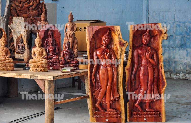
The village of Ban Thawai, close to the town of Hang Dong, Chiang Mai, is a well known centre that has specialised in the preservation of the skills of woodcarving. Its exquisite woodcarving features a diversity of exotic indigenous styles such as Lanna, Chiang Saen, Burmese, Chinese and Tibetan. Traditional folk skills and expertise in the ancient art of woodcarving have been passed down through the generations and Ban Thawai has established a name for itself.

ban-thawai-woodcarving-village-by-tw-02
ban-thawai-woodcarving-village-by-tw-03

The growing demand for traditional woodcarvings as decorative items has contributed to the revival and preservation of folk art and culture and encouraged the community to preserve the artistic value of its village crafts. With the establishment of export companies in the village, the carved products are now spread around the world and their quality is recognised internationally. This cottage industry is now a major tourist attraction, generating sustainable income for the community.

For taxi : บ้านถวาย


Wat Phra That Si Chom Thong

wat-phra-that-si-chom-thong-by-123-tw-01

This temple is located in Chom Thong county, 58 km. from Chaing Mai town, and dates from the mid-14th century. Its Burmese-style bot (main chapel) is one of the most beautiful in northern Thailand. Like many other temples in the province, it is a typical Lanna Thai work of art.

For taxi : วัดพระธาตุศรีจอมทอง


Wiang Tha Kan

There are ruins of an ancient walled city, built in the 8th century, located in the village of Ban Tha Kan, San Pa Tong county, 34 km. to the south of Chiang Mai. The ruins include a pagoda and the foundations of the vihara, built of bricks and laterites. Most of the relics are Buddha images made of sandstone and clay.

For taxi : เวียงท่ากาน


Ban Rai Phai Ngam Cotton Weaving Village

This is a village where cotton cloth woven in the old style has long been produced. At present the weavers' central gathering place is the home of the late National Artist, Mrs. Saengda Bansit, who had imparted her knowledge about the weaving process to the villagers. The village is located on the left of Chiang Mai - Hot Route and can be reached by a 4-km side road which joins the main road at a point between Km. 68 and Km. 69.

For taxi : บ้านไร่ไผ่งาม


Doi Tao Lake

This scenic place offers boat riding and rafting. There are several types of boats and rafts for travellers to choose from. Rates depend on distance and number of passengers. To reach the lake, drive along Highway 108 for 90 kms and turn left to Highway 1130 and proceed for 35 kms. to Doi Tao.

For taxi : ทะเลสาบดอยเต่า


Ob Luang Gorge in Ob Luang National Park (696 km north of Bangkok)

The gorge is where a steep river valley amid scenic mountains and teak forests is situated. Ob Luang Gorge features a swift river flowing through a twisted course, which is a challenge for rafters.

ob-luang-national-park-by-123-tw-01

Ob Luang Gorge National Park also offers routes for natural and prehistoric expeditions. To enter the prehistoric site of the park, you have to cross the bridge over the gorge which is quite blood curdling. In addition, there is situated Thepphanom hot-spring pond whose temperature remains at 99 degrees Celsius.

Recommended time: All year round, especially in the dry season around January when trees in deciduous dipterocarp forests are shedding leaves.

How to get there: From Chiang Mai Town, use Highway 108 to Hot County and then turn right onto Mae Sariang County for about 22 km. The route will lead to Ob Luang Gorge National Park.

For more information, please contact: TAT Northern Office Region 1 on tel: 0 5324 8604, 0 5324 1466.

If you are interested in going to any place mentioned here, you are recommended to find additional essential information before starting out on your trip.

For taxi : ออบหลวง


Mae Ya Waterfall

mae-ya-waterfall-by-123-tw-01

This beautiful fall is located in Chom Thong county, 70 km. from Chiang Mai. The clear water of this 280-metre-high waterfall splashes down over 30 tiers of rocks into small pools.

For taxi : น้ำตกแม่ยะ

Doi Inthanon National Park

Covering an area of 1,005 sq.km. and being 2,565 m. above sea level, Doi Inthanon is the highest mountain of Thailand and one of the most popular national parks. The higher hills at 1,800 m. and up are often shrouded in mist, especially in the rainy season.

According to surveys, there are no less than 380 species of birds living in the park, mostly in thick evergreen forest betweeen 1,500 and 2,000 m. in altitude. The best places to watch birds are at the summit and around the bogs. Along the 47 km. road to the top are many terraced rice fields, large valleys and some hilltribe villages, mostly inhabited by Karens and Hmongs.

Points of Interest

Most visitors to the park go by car all the way to the summit where to enjoy the cool and fresh air and the magnificent wide view of the entire basin of Chiang Mai. On their way up or down, they can stop to visit three well-known waterfalls of the park, viz. Mae Klang, Wachirathan and Siriphum.

Mae Klang is the largest waterfall and the easiest to get to. Just next to the waterfall is Borichinda Cave which has beautiful stalactites and stalagmites and a small stream inside.

mae-klang-waterfall-by-123-tw-01

Mae Klang

twin-royal-pagoda-by-123-tw-01

Twin Royal Pagodas

There are also vantage points along the road to view the scenic landscape. The most impressive are the Twin Royal Pagodas which contain the Buddha's relics and were built by the Royal Thai Air Force in commemoration of the 60th birthday of Their Majesties The King and Queen in 1987 and 1992 respectively. For nature trekkers and bird watchers, many trails are available, some of which are old routes used by hilltribes.

Visiting Doi Inthanon National Park is possible throughout the year, but the best period for viewing the forest is November through February.

For accommodation, contact the national park office at Km. 31.

How to Get to Doi Inthanon

The most convenient way to go to Doi Inthanon is joining a guided tour party. But getting there by yourself is also enjoyable.

Follow Highway 108 from Chiang Mai. At Km. 57 just 1 km. before Chom Thong District, turn right to Highway 1009 for 8 km. to the fork and turn right to the summit. The total distance is 106 km. As some sections of the road are steep, a good car and an experienced driver are needed.

From Chiang Mai town, you may also take a bus to Chom Thong which leaves regularly from just inside the Chiang Mai Gate at the south moat. From Chom Thong, there are regular songthaeos (mini-buses) to Mae Klang Waterfall, where you can take another songthaeo to Doi Inthanon.

Notes: As it is cool almost all year round on the top of Doi Inthanon, especially in winter when the temperature may fall below 10° C, don't forget to bring a jacket or a sweater with you.

For taxi : ดอยอินทนนท์

Read more about Doi Inthanon National Park

twin-royal-pagoda-by-123-tw-01

The Great Holy Relics Pagoda of Nobhamethanidol-Nabhapolbhumisiri

mae-klang-waterfall-by-123-tw-01

Mae Klang Waterfall

How to Get to Doi Inthanon

The Legend of Doi Luang Ang Ka

The highest mountain of Thailand “Doi Inthanon” or Mt Inthanon was formerly known in the northern dialect as “Doi Luang Ang Ka”, which conveys its colossal size and feature. Legend has it that Mt Inthanon once contained a huge reservoir or “Ang” in Thai. This reservoir was where crows or “Ka” usually came to drink water. So the locals named the mountain the “big crows’ reservoir mountain”. After the 7th ruling prince of Chiang Mai, Chao Intha Wichayanon, who once came to explore the mountain passed away, his daughter, Chao Dara Ratsami, buried her father’s ashes here to fulfill his wish. Then Doi Luang Ang Ka was given the new name “Doi Inthanon”. In 1972, Doi Inthanon was declared the 6th national park of Thailand.

A Trip to Doi Inthanon

Situated in the Thanon Thong Chai Mountain Range, covering an area of 1,005 sq km and being 2,565 m above sea level, Doi Inthanon is the highest mountain of Thailand and one of the most popular national parks of this country. The hills at 1,800 metres and up are often shrouded in mist, especially in the rainy season. Doi Inthanon, one of the must see places in Thailand, is well known for its cool climate all year round, its ancient forests, frozen dew (Mae Kha-ning), Delavay’s Rhododendron (1,000-year roses), wild flowers, wildlife, hilltribe culture and step farming.

To reach the summit is convenient. You can either drive or hire a minibus labelled Doi Inthanon in English from Mae Klang Waterfall or Wat Phra That Chom Thong. A regular minibus running to the Park Headquarters (km 31) can also be taken at either place at a lower fare.

In case of driving by yourself, make sure that your vehicle is in good condition since you will have to go up and down steep hills. Although Mt Inthanon is accessible any time of the year, the best period is between November and February when it is always fine and clear.

Attractions in Doi Inthanon

mae-klang-waterfall-by-123-tw-01

Mae Klang


Mae Klang (km 8) is a large waterfall and the easiest to get to. The waterfall is the first gate to Doi Inthanon National Park. It is beautiful and has water all year round; therefore many Thais come to swim, picnic and relax here on a sunny day.

At the side of the falls, there is a trekking trail to the Tourist Service Centre (km 9), where you can admire the exhibitions of nature and wildlife in Doi Inthanon.

Borichinda Cave (km 8.5) is located next to Mae Klang Waterfall. The limestone cave has beautiful stalactites and stalagmites and a small stream inside. When glittering in the sunlight, the cave is extremely gorgeous.

Wachirathan (km 21) is a big waterfall that can be reached by a short trail from the parking area. Near the waterfall, the slippery wooden walkway leading to the cliff is always wet and shrouded in mist.

Siriphum (km 30) -- The twin streams of water flowing down a stiff cliff can be seen from the Park Headquarters. The waterfall is located near the Hmong village and is accessible by foot only.

The Park Headquarters & Doi Inthanon Royal Project (km 31) -- Set up to promote highland agriculture alternatives among the Karens and Hmongs, this Royal Project features temperate flower, fruit, and vegetable plots and their nursery labs. You can also visit Hmong’s flower plots at the front of the Royal Project. Delicious food made from fresh temperate vegetables and freshly blended coffee are served at the Royal Project Restaurant.

Hmong Market (km 31) -- Driving up to Doi Inthanon, you shouldn’t miss shopping for handmade products, temperate vegetables, flowers and freshly picked fruits from tribal sellers dressed in colourful embroidered costume at Hmong Market.

The Great Holy Relics Pagoda of Nobhamethanidol-Nabhapolbhumisiri (km 41.5) are constructed by the Thai Air Force and Thai people on the auspicious occasion of King Bhumibol’s 5th cycle birthday in 1987 and Queen Sirikit’s 5th cycle birthday in 1992 respectively. The Buddha’s relics are kept inside the Nobhamethanidol pagoda.

twin-royal-pagoda-by-123-tw-01

In the outer parts, the two pagodas feature beautiful tiled murals and vantage points where visitors can see or photograph a magnificent panoramic view of Doi Inthanon. The surrounding areas are decorated with beautiful temperate flowers and plants.

The Highest Spot in Thailand (km 48) -- Highway 1009 ends at the highest spot in Thailand (2,559 m) at the summit of Doi Inthanon. The mountaintop covered with patches of fog and frosted leaves is breathtaking. It is where the Radar Station of the Thai Air Force and the stupa of the last governor of Chiang Mai are located. And not far from the summit is a Tourist Public Relations Centre where the stories of Doi Inthanon in the past are exhibited. Tourists can learn the geography, biology, and forestry of the area as well as the wildlife that exists here.

Bird Watching and Trekking in Doi Inthanon

For nature trekkers and bird watchers, many trails are available in Doi Inthanon, some of which are old routes used by hilltribes. The cool climate and unique environment in Doi Inthanon make it home to the largest number of bird species in Thailand. According to surveys, there are no less than 380 species of birds living in the park, mostly in thick evergreen forest between 1,500 and 2,000 m in altitude. Over 190 species are reported as common residents here. The best places to watch birds are at the summit and around the bogs. Bird watching in Doi Inthanon can be done throughout the year.

The most popular period is probably during the cold season (October-January) since migratory birds are found there. Summer time (February - April) is when most resident species are calling, singing, and breeding which make them easily noticed.

The baby-feeding period between May and July is a quite interesting time for bird watchers as well. In August and September, the rain is a bit of a problem for bird watching.

Uncle Daeng’s Café (km 31) -- Another recommended place is the Bird Watching Centre at the Mae Klang Watershed Management Unit, or known as Uncle Daeng’s Café. This is where advice from bird watchers from all over the world and information on birds found in Doi Inthanon, including their route maps and photographs, are exchanged and kept for the next generations. Meals and a guide to take you to watch the birds are available here.

Kiu Mae Pan (km 42) is a terrific place for those who want to explore the sub-alpine ecosystem. The trail through the moist evergreen forest leads the trekkers to see the canyon and creeks. While walking pass the cliff edge covered with a blanket of fog, you will see Red Rhododendron, a very rare and beautiful native flower of the Himalayas and a variety of rare wild flowers.

The Red Rododendron is in bloom during the period between December and February. You will also witness some other native Himalayan plants thriving in an open filed with green grassland and sunlight. In the cool weather and scenic shady path, you will hear birds partying on the big trees. Species commonly found here are Green-tailed Sunbirds, Flycatchers and Vivid Niltava. Permission from the National Park Public Relations Centre and a guide for each group of 15 people are needed before entering the trail. This 3-km route was given an eco-tourism award in 2002 as it focuses on the real ecological characteristic and has signs to provide visitors with useful information. Kiu Mae Pan is closed from 1 June to 30 October each year.

Ang Ka (km 48), a combination of the highland peat swamp and hill evergreen forest situated at the mountaintop, features a special eco-system found nowhere else. Follow a 400-m-long wooden bridge; you will be introduced to a unique atmosphere of the Himalaya.

Ancient tall lichen-clad trees hidden amid seas of fog and rare species of flora and fauna together with hundreds of birds have enticed visitors to the Ang Ka for many years.The birds’ annual feast begins in the cold season when wild flowers, especially red Rhododendrons, dotted the forests. Green-tailed sunbirds, chestnut-tailed minlas, rufous-winged fulvettas and several others are commonly found here. This is a real bird lovers’ paradise.

City TourDoi Suthep RouteMae Rim - Samoeng Route • Chiang Mai - Chom Thong - Hot Route (to Doi Inthanon National Park) • Bo Sang - San Kamphaeng RouteMae Taeng - Chiang Dao - Fang Route


Bo Sang and Sankamphaeng Villages are among the old tourist spots of Chiang Mai which have got fame for their fine products -- umbrellas, Thai silk and cotton. Nowadays this route is dotted with manufacturing centres of silverware, wood carving, ceramics, weaving and embroidery as well.

Bo Sang Umbrella Village

bo-sang-umbrella-by-tw-03
bo-sang-umbrella-by-tw-05

(9 km. on Route 1006 / see Map of Chiang Mai City)

In this village of cottage industries, visitors can view young women in traditional costumes hand-paint silk and cotton umbrellas in various animal and floral designs. There are also craft shops selling various northern Thai handicrafts.

For taxi : หมู่บ้านทำร่มบ่อสร้าง สันกำแพง


San Kamphaeng Cotton & Silk Weaving Village

This famous village, located 4 km. further down the same route, is the major production centre of Thai silk and cotton.

The good quality fabrics are woven by local folk on traditional wooden looms and are available in a wide variety of patterns.

For taxi : หมู่บ้านทอผ้าไหมและผ้าฝ้าย อ.สันกำแพง


San Kamphaeng Hot Springs

san-kamphaeng-hot-springs-by-tw-04
san-kamphaeng-hot-springs-by-tw-05

This is located 36 km. from town amid natural surroundings of trees and lush hills. The water has a high sulphur content and possesses curative and restorative properties. Accommodations, dining facilities and mineral water bathing rooms are available.

For taxi : น้ำพุร้อนสันกำแพง

Mae Taeng - Chiang Dao - Fang Route (Highway 107)

THE LANDMARKS OF BANGKOK TOUR

MORE

The Landmarks of Bangkok Tour

The program including 4 temples and 1 palace: Wat Arun (The Temple of Dawn), Wat Benchamabopith (The Marble Temple), Wat Trimitr (The Golden Buddha), Wat Pho (The Temple of Reclining Buddha), The Grand Palace & The Temple of the Emerald Buddha (Wat Pra Kaew).


DAMNOEN SADUAK FLOATING MARKET

MORE
damnoen saduak floating market

Damnoen Saduak Floating Market Tour

This authentic floating market is one of the most photographed places. It is located in Ratchaburi, about 100 km from Bangkok. Take a long-tail boat to the Floating Market where you will see the lifestyle of Thai people along the canal. Many vendors floating in their small rowing boats selling local food.


logoAlex Holiday is a Bangkok-based travel agent, operating tour services and providing hotel reservations all over Thailand. We specialize in cultural, trekking, adventure and golf tours as well as other tailor-made tour packages. We can organize all kinds of travel for you. More details...


PATTAYA

MORE

Pattaya Beach

Pattaya Beach is divided into the north, central and south zones. The beach offers excellent facilities for watersports enthusiasts of all kinds.


PHUKET

MORE

Patong Beach

Patong is the most famous beach in Phuket. With its wide variety of activities and nightlife, it is an ideal place to relax, party and play.


SAMUI

MORE

Chaweng Beach

This 7-km beach is the longest and the most popular beach on the east coast of Ko Samui. It has clean white sand and clear blue water.


HUA HIN

MORE

Hua Hin Beach

A popular beach destination about 3-hour drive from Bangkok. Its long sandy beach with a relaxed atmosphere is great for family holiday.